GoPilot-MethaneMapper: A Physics-Informed Platform for Sentinel-2 Methane Emission Quantification
Abstract
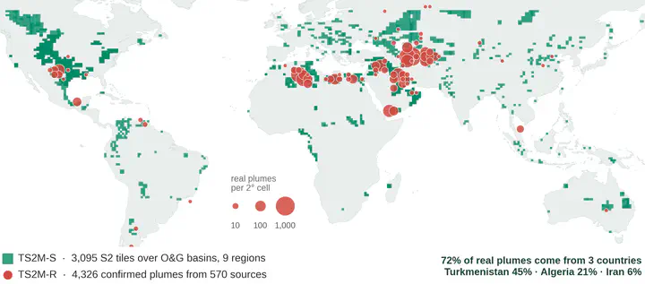
Methane is a potent greenhouse gas, and rapid detection and quantification of large point-source emissions are important for climate monitoring and mitigation. Sentinel-2 provides a practical means of monitoring methane emissions at a global scale. However, existing real-world datasets are limited in size, geographically biased, and subject to annotation uncertainty, constraining the development of reliable models for methane plume detection and emission quantification. This work presents GoPilot-MethaneMapper, a physics-informed platform for methane plume detection and emission quantification from Sentinel-2 imagery. A key contribution is TS2M-S, a large-scale physics-based synthetic dataset designed for Sentinel-2 methane plume detection and emission quantification. The dataset is generated by combining Gaussian-puff plume dispersion with radiative-transfer modelling to simulate the effect of atmospheric methane on Sentinel-2 SWIR reflectance, incorporating instrument-specific spectral response functions and HITRAN molecular absorption data. Synthetic plumes are embedded into authentic Sentinel-2 background scenes spanning diverse geographic and atmospheric conditions, resulting in approximately 550,000 samples with precisely controlled plume geometry and emission rates. A separate real-world validation dataset, TS2M-R, is manually curated from expert-confirmed Sentinel-2 methane detections in the UNEP Eye on Methane catalogue. This controlled framework provides accurate ground truth for both plume detection and methane flux quantification, while enabling systematic evaluation across a wide range of emission scenarios. GoPilot-MethaneMapper uses a U-Net-based segmentation architecture to detect methane plumes in multi-temporal Sentinel-2 imagery. We investigate the contribution of synthetic training data and different temporal reference strategies to detection performance, and evaluate methane emission quantification from the detected plumes. The platform is deployed in the cloud, supporting on-demand scaling and low-latency warm-instance inference. GoPilot-MethaneMapper was selected as a winning project in the AWS GenAI for Geospatial Challenge, supporting the transition from research to scalable cloud-based methane monitoring.